 |
|
|
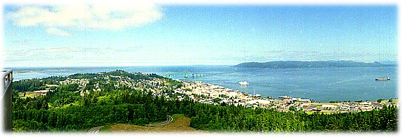
Onward and upward, in latitude and elevation ... we approached Astoria, the oldest West Coast city, a "placid amalgamation of small town and hard-working port city," said the book. I don't know about that, but it's on one amazing peninsula, spectacularly set — flanking the mouth of the (mighty) Columbia River as it meets the (awesome) Pacific Ocean. On its southern side are Young's Bay, Young's River and the Lewis & Clark River. Oh yes, the town itself sits atop and along Coxcomb Hill, which rises 600 feet above the river. So all the makings are there for grand 360-degree views ...
It was a pretty good climb to the top, 164 steps of winding stairway. But what a beautiful view from the top on this clear day. I had the small balcony all to myself for awhile, and savored ... For an extra-wide look at the vista, click here. The Columbia is pretty impressive in girth here — it's as wide as five miles near Astoria, and looked completely different than it did in the Gorge area. Ships were entering its mouth, and a barge was headed west toward the Pacific. And off to the east, I saw a peak that looked an awful lot like Mt. St. Helens — it had a big gap in its center. The guide below told us no, it wasn't ... but the literature said it could be seen from the Column. So that's my story — I saw it.
There were two lighthouses in the area, the first — Cape Disappointment Light — is the oldest (1856) and highest on the Washington coast at 220 feet above the Ocean. We had to hike close to a mile to reach the Light, passing a tempting green lagoon on the way. People were swimming, so the water temperature must have been tolerable. It was a tropical-looking spot, here in the Northwest. The Light looked good for its advanced age ... beneath it, a rocky cape and sandbar area called the "graveyard of the Pacific" where more than 250 ships have run aground and sunk.
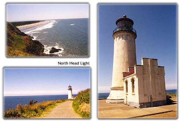
A few miles further north was another great old lighthouse, North Head Light. This one was built in 1898. After another hike, we rounded a bend to find ourselves high above the Pacific, and the 65-foot Light at the end of our trail. What an incredible spot; it was very windy and the cliffs very steep. I felt like I'd be blown off the side as I took photos from just below the Light.
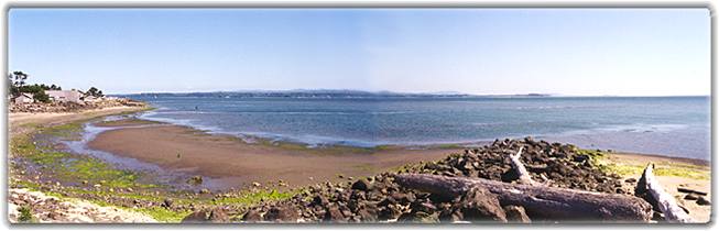
We decided not to continue up Long Beach peninsula; instead we got back on 101 north and drove around the perimeter of Willapa Bay. Pretty marshes and nice towns kept me entertained. One sign proclaimed the high school team nickname: the Chokers. We rounded the north end and took 105 to stay along the coast. A short detour out to a small village, Tokeland ... though just a few miles from the main road, it felt very isolated and relaxed there. This was their view south, down Willapa Bay ...
But, we thought, it's still pretty early and there are some "big text" towns ahead, no problem finding a nice spot to stay. Well, not much in Aberdeen it turned out; but there's always Hoquiam, right on the harbor. It was a strange small city ... busy streets, which we weren't used to, and not much in the way of scenery, also unusual. So we gave up, and found a cookie cutter motel to collapse in. Food was still high on the priority list ... and the restaurant across the street was recommended by the motel manager and the guide book. The menu looked good, the waitress approached. Is the Captain's choice broiled? I asked. Yes. Are the the shrimp and scallops broiled? Peter asked. Yes. As the meals are being delivered, I noticed an oily wake in the air trailing the plates. So much fried batter, no seafood was visible. Anger gave way to hunger ... Next time, Peter said, we ask "How is that prepared?"
© 2000 CCarnovale Home | Web Design | Graphics | Photos | Travels
|
 As
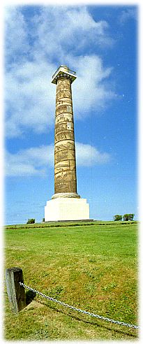
if that wasn't enough ... they decided to put a monument — a 125-foot
column — at the top of Coxcomb Hill. Not your ordinary column,
mind you, but one with a pictoral frieze of 14 scenes that chronical
the history of the Northwest Territory. The Astoria Column; a unique,
beautiful structure. It was dedicated in 1926; and a recent restoration
has brought back the original brown and ochre colors that had deteriorated
over years of coastal storms.
As
if that wasn't enough ... they decided to put a monument — a 125-foot
column — at the top of Coxcomb Hill. Not your ordinary column,
mind you, but one with a pictoral frieze of 14 scenes that chronical
the history of the Northwest Territory. The Astoria Column; a unique,
beautiful structure. It was dedicated in 1926; and a recent restoration
has brought back the original brown and ochre colors that had deteriorated
over years of coastal storms. 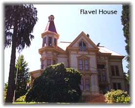 We
drove around Astoria a bit. Pretty, hilly streets with nice homes, some
stately Victorians. I wanted a closer look at the Astoria-Megler Bridge
before we crossed it. So we drove down to the waterfront. It's a massive
structure — the world's largest continuous truss bridge. Some facts:
it opened in 1966, the main span is 1,232 feet long and 198 feet above
the low-water mark. So it allows some big vessels to sneak by underneath.
The total length is 4.1 miles ...
We
drove around Astoria a bit. Pretty, hilly streets with nice homes, some
stately Victorians. I wanted a closer look at the Astoria-Megler Bridge
before we crossed it. So we drove down to the waterfront. It's a massive
structure — the world's largest continuous truss bridge. Some facts:
it opened in 1966, the main span is 1,232 feet long and 198 feet above
the low-water mark. So it allows some big vessels to sneak by underneath.
The total length is 4.1 miles ... 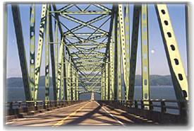 Time
to leave Oregon, reluctantly. But Washingon ahead, Woo hoo! The shore
was immediately beautiful and interesting as we got off the bridge.
Our first stop would be a place we had seen from the Column, Cape Disappointment.
We went a bit west, passing through Ilwaco, then turned south to get
to the lowest part of the Long Beach peninsula.
Time
to leave Oregon, reluctantly. But Washingon ahead, Woo hoo! The shore
was immediately beautiful and interesting as we got off the bridge.
Our first stop would be a place we had seen from the Column, Cape Disappointment.
We went a bit west, passing through Ilwaco, then turned south to get
to the lowest part of the Long Beach peninsula.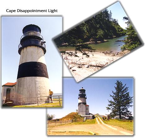
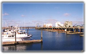 Another
side trip up to Westport; its tip extended into Gray's Harbor. This
was a cute fishing port, and also had some nice small shops and restaurants.
Some good
friends live in another Westport 3000 miles to the east, on another
ocean, so I thought I'd send them a postcard from this "sister"
town. In retrospect, that was where we should have spent the night.
Another
side trip up to Westport; its tip extended into Gray's Harbor. This
was a cute fishing port, and also had some nice small shops and restaurants.
Some good
friends live in another Westport 3000 miles to the east, on another
ocean, so I thought I'd send them a postcard from this "sister"
town. In retrospect, that was where we should have spent the night.